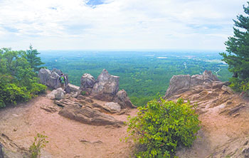
 The beauty and diversity of Crowders Mountain State Park are best appreciated on its miles of hiking trails. Hiking trails lined with wildflowers and mountain laurel lead along the ridges and to the summits of Crowders Mountain and Kings Pinnacle. Other trails are easy promenades through pastoral surroundings. Circle the lake on a gravel path or view aquatic plants and animals along a narrow creek. Bring a pair of binoculars and do some bird watching or tote a camera and capture the beauty of wildflowers in bloom.
Three park, two state, one trail hike planned...
Join staff and volunteers from Kings Mountain Military Park, Kings Mountain State Park, and Crowders Mountain State Park for a full day of hiking on our annual three parks hike. This is a strenuous, fifteen-mile hike that begins at Crowders Mountain State Park and ends at Kings Mountain Military Park in South Carolina. Hikers plan on meeting at the upper picnic shelter parking lot at the Sparrow Springs Access Area (522 Park Office lane, Kings Mountain, NC 28086) at 8:15 AM. Lunch will be provided at the Boulders Access Area for hikers by the Friends of Crowders Mountain, Inc. From there, the hike will continue through Kings Mountain State Park and end at Kings Mountain Military Park. A shuttle will be provided by the Friends of Kings Mountain State Park to carry hikers back to Crowders Mountain at the end of the hike. The hike will end around 4:45 PM. If you are interested in the hike please call the park office at (704)853-5375 to register and for more details.
Hike Length and Difficulty: Strenuous 15 miles
Date of Event: Saturday, April 21, 2018 - 8:30am to 5:00pm
Start Location: Picnic Shelter #2 Parking Area @ Crowders Mountain State Park.
Crowders MOUNTAIN Trails
Backside Trail
Location: starts at the Linwood Access Area and ends at the summit of Crowders Mountain
Description: Just before reaching the summit, hikers will climb up 336 wooden steps.
Length: 0.90 miles One-way
Difficulty: Strenuous
Blaze: orange hexagon
Surface: Gravel, Stairs
Crowders Trail
Description: The trail includes one state road crossing, and provides access to the Crowders summit via the Backside Trail.
Length: 2.80 miles One-way
Difficulty: Moderate
Blaze: white diamond
Surface: Natural surface
Family Camping Trail
Description: The trail gives campers access to the family backpack camping area.
Length: 1.00 milesOne-way
Difficulty: Moderate
Blaze: red square with a single tent
Surface: Natural surface
Fern Trail
Location: This loop trail connects with a portion of the Turnback Trail and follows a creek for some portions of the trail.
Description: This loop trail connects with a portion of the Turnback Trail and follows a creek for some portions of the trail. Crowders Mountain State Park's TRACK Trail adventures were designed for use on the Turnback Trail, Fern Trail, and Lake Trail. These three trail combined make a 2.1 mile round-trip hike.
Length: 0.80 miles Round Trip
Difficulty: Easy
Blaze: red hexagon
Surface: Natural surface
Group Camping Trail
Location: The trail gives campers access to the group backpack camping area
Description: The trail gives campers access to the group backpack camping area.
Length:1.00 miles One-way
Difficulty: Moderate
Blaze: light blue diamond with three tents
Lake Trail
Location: Sparrow Springs Access. Starts and ends at the park lake
Description: The trail circles the park lake. Crowders Mountain State Park's TRACK Trail adventures were designed for use on the Turnback Trail, Fern Trail, and Lake Trail. These three trails combined make a 2.1 mile round-trip hike.
Length: 0.80 miles Round Trip
Difficulty: Easy
Blaze: light blue circle
Surface: Natural surface
Pinnacle Trail
Location: Sparrow Springs Access. Begins at the Visitor Center and ends at the summit of King's Pinnacle. Description: King's Pinnacle is the highest point in Gaston County at 1,705 feet.
Length: 2.00 miles One-way
Difficulty: Strenuous
Blaze: orange circle
Surface: Natural surface
Ridgeline Trail
Location: Sparrow Springs Access. The trail starts near the summit of Kings Pinnacle, and follows the ridgeline all the way to the South Carolina State line.
Description: The Ridgeline trail continues for 2.5 miles into South Carolina through Kings Mountain State Park, and terminates at the 16 mile Kings Mountain National Recreation Trail that goes through Kings Mountain State Park and Kings Mountain National Military Park.
Length: 6.20 miles One-way
Difficulty: Moderate
Blaze: red triangle
Surface: Natural surface
Rocktop Trail
Location: Linwood Road Access. starts at the road crossing of Sparrow Springs Road and Freedom Mill Road and ends at the summit of Crowders Mountain
Description: There is no parking at either end of the trail and the trail must be accessed by either beginning on the Crowders Trail (visitor center) or the Tower or Backside Trails (at the Crowders summit). This trail crosses several rock ledges and requires good footwear and careful attention to staying on the trail.
Length: 1.40 miles One-way
Difficulty: Strenuous
Blaze: red square
Surface: Natural surface
Tower Trail
Location: Begins at the Linwood Access Area and ends at the radio towers on Crowders Mountain.
Description: The trail is an old roadbed that begins with a gentle climb that becomes quite steep towards the end. Please note that business vehicles use this trail to access the radio towers near the summit.
Length: 1.80 miles One-way
Difficulty: Strenuous
Blaze: light blue square
Surface: Gravel
Turnback Trail
Location: Sparrow Springs Access. Begins at the southeast corner of the visitor center parking lot and ends at the Pinnacle Trail 0.7 miles from the summit of King's Pinnacle.
Description: The trail gives alternate hiking opportunities for both the Pinnacle and Fern trails. Crowders Mountain State Park's TRACK Trail adventures were designed for use on the Turnback Trail, Fern Trail, and Lake Trail. These three trail combined make a 2.1 mile round-trip hike.
Length: 1.20 miles One-way
Difficulty: Moderate
Blaze: white triangle
Surface: Natural surface
by NC Div. of Parks and Recreation
Photo by AllTrails |